


Wallingford 5 Voting District, New Haven County, Connecticut
About
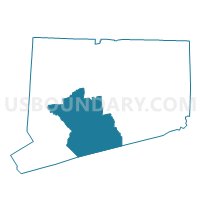
Outline

Summary
| Unique Area Identifier | 550015 |
| Name | Wallingford 5 Voting District |
| County | New Haven County |
| State | Connecticut |
| Area (square miles) | 3.76 |
| Land Area (square miles) | 3.75 |
| Water Area (square miles) | 0.01 |
| % of Land Area | 99.81 |
| % of Water Area | 0.19 |
| Latitude of the Internal Point | 41.44613950 |
| Longtitude of the Internal Point | -72.84775090 |
Maps


Graphs
Select a template below for downloading or customizing gragh for Wallingford 5 Voting District, New Haven County, Connecticut


Neighbors
Neighoring Voting District (by Name) Neighboring Voting District on the Map
- Hamden 1 Voting District, New Haven County, CT
- North Haven 4 Voting District, New Haven County, CT
- North Haven 5 Voting District, New Haven County, CT
- Wallingford 2 Voting District, New Haven County, CT
- Wallingford 4 Voting District, New Haven County, CT
- Wallingford 6 Voting District, New Haven County, CT
- Wallingford 8 Voting District, New Haven County, CT
Top 10 Neighboring County Subdivision (by Population) Neighboring County Subdivision on the Map
- Hamden town, New Haven County, CT (60,960)
- Wallingford town, New Haven County, CT (45,135)
- North Haven town, New Haven County, CT (24,093)
Top 10 Neighboring Place (by Population) Neighboring Place on the Map
Top 10 Neighboring Unified School District (by Population) Neighboring Unified School District on the Map
- Hamden School District, CT (60,960)
- Wallingford School District, CT (45,135)
- North Haven School District, CT (24,093)
Top 10 Neighboring State Legislative District Lower Chamber (by Population) Neighboring State Legislative District Lower Chamber on the Map
- State House District 88, CT (24,771)
- State House District 87, CT (24,093)
- State House District 85, CT (23,261)
- State House District 103, CT (22,818)
- State House District 90, CT (22,544)
Top 10 Neighboring State Legislative District Upper Chamber (by Population) Neighboring State Legislative District Upper Chamber on the Map
Top 10 Neighboring 111th Congressional District (by Population) Neighboring 111th Congressional District on the Map
Top 10 Neighboring Census Tract (by Population) Neighboring Census Tract on the Map
- Census Tract 1755, New Haven County, CT (7,905)
- Census Tract 1671, New Haven County, CT (7,743)
- Census Tract 1660.02, New Haven County, CT (7,726)
- Census Tract 1672.02, New Haven County, CT (4,485)
- Census Tract 1754, New Haven County, CT (4,431)
- Census Tract 1753, New Haven County, CT (4,327)
- Census Tract 1751, New Haven County, CT (3,244)
- Census Tract 1752, New Haven County, CT (2,315)